Lacey Swope: Winds, Fire Danger, And Rain Chances This Week
Meteorologist Lacey Swope is breaking down the conditions this week as we face fire danger, high winds, chances for rain, and more!Monday, October 28th 2024, 8:31 am
Buckle up because this week's forecast is a whirlwind—quite literally!
We're in for a mix of high winds, potential fire hazards, and a glimpse of much-needed rain on the horizon.
Here is a breakdown of what to expect.
Extreme Wildfire Danger
Today, all the ingredients are coming together for large wildfires. We may not see any fires break out, but if they do, they could burn out of control quickly. Winds will ramp up throughout the day, with gusts from the south reaching 40 mph, and a few gusts could reach 50 mph. Humidity will plummet in the west, dropping to 15% in our western counties, while humidity will be slightly higher in central and eastern Oklahoma. Highs today will be close to record levels; temperatures are expected to climb into the 80s and even the 90s, when we should typically see highs in the 60s this time of year.
Tonight, the winds will remain strong, but Gulf moisture will surge in, bringing clouds and a chance for patchy drizzle in the south and east. The higher humidity will help reduce the wildfire danger tomorrow, but the winds will still be very strong.

Storm Chances
On Wednesday, the upper-level storm driving our winds will arrive, bringing a cold front crashing in from the north. A dryline will also set up to our west. Ahead of these boundaries, strong south winds will increase moisture and instability, fueling storms that are expected to develop in the afternoon and evening. The exact timing and location of these storms may shift, so stay tuned to the forecast. As of now, the threats include large hail up to the size of quarters and damaging winds up to 70 mph. The tornado threat appears extremely low, but that could change. We desperately need moisture, and this will be the first of many storm chances for Oklahoma. These storms will move through quickly and bring some decent rain, but they won't impact the entire state.

Halloween
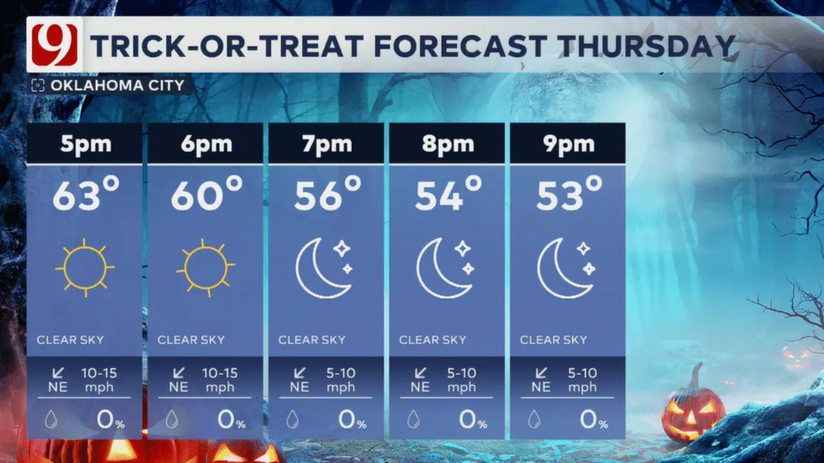
Trick-or-treat weather looks wonderful this year! Expect dry conditions with clear skies and temperatures in the 60s, falling into the 50s as the night progresses.

Weekend Soaker
Soaking rain is on the way with a slowly moving upper-level low. Rain chances will increase on Saturday and last through early next week. We could see round after round of heavy rain and storms. If storms train over the same areas, we may experience some flooding across Oklahoma. The projected rainfall totals are impressive, but they may vary as the event approaches. Right now, one to two inches of rain looks very likely, with some areas potentially seeing triple that. This rainfall will significantly help alleviate the ongoing drought.

More Like This
October 28th, 2024
January 10th, 2025
January 10th, 2025
January 10th, 2025
Top Headlines
January 9th, 2025
January 9th, 2025
January 9th, 2025


